Los Angeles International Airport (LAX)
Orientation and Maps
(Los Angeles, California (CA), USA)
Los Angeles, or 'LA' as it is often known, is an iconic city, widely associated with America's movie business. The home to many famous celebrities, Los Angeles is the ultimate Californian city, with plenty of sunshine, beaches and attractions for everyone, including the Sunset Strip, the Walk of Fame, and the famous shops along Rodeo Drive.
Each year many thousands of tourists fly into the city, in search of glamor and excitement. The Los Angeles International Airport (LAX) lies on the southwestern side of the city and is the premier airport. Nearby, the much smaller Hawthorne Municipal Airport (HTH) features domestic flights only.
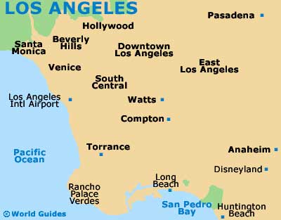
Los Angeles Airport (LAX) Maps: Important City Districts
The city's Greyhound bus station is situated along East 7th Street and features plenty of long-distance buses and local city buses, which travel to the Hollywood bus terminal on North Cahuenga Boulevard, amongst other locations. The Los Angeles Union Station can be found along North Alameda Street and features many regular Amtrak trains, connecting major cities, such as Chicago, Santa Barbara and San Diego.
Downtown Los Angeles has an extraordinary amount of attractions of offer, which are extremely varied to say the least. With historic architecture, popular eateries, shopping complexes and many cultural institutions, the downtown district is easy to walk around and this is by far the best way to sightsee here. Highlights include the Civic Center, the eye-catching City Hall, and the truly breathtaking Walt Disney Hall.
Other important districts within the city of Los Angeles include Little Tokyo, the Exposition Park area, Hollywood, Beverly Hills, Malibu, Santa Monica and Long Beach.
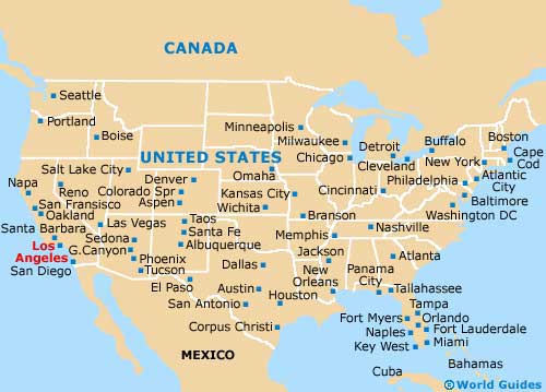
USA Map
California Map

Los Angeles Map